


PrecisionFlight for DJI Drones
Beschreibung von PrecisionFlight for DJI Drones
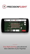
PrecisionHawk’s PrecisionFlight mobile app turns a DJI drone into an advanced remote sensing tool—empowering drone pilots to capture aerial data autonomously. Create flight plans, record video, and capture aerial imagery—all with the push of a button.
Key features include an intuitive and simple flight planning interface; autonomous takeoff, survey mission, and landing; automatic determination of most efficient flight path for data collection including orbit missions around any point of interest; and real-time flight monitoring including altitude, ground speed, mission progress, battery and signal strength, GPS, live video feed, and flight trail.
Additional features:
- Producing flight plans, including grid, orbit, and video capture modes
- Pre-flight checks and emergency safety features like emergency landing and return to home (RTH) technology
- Ability to pause and resume missions
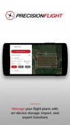
- Storage of flight plans for easy flight plan management
- Online and offline flight planning capabilities with storage of basemaps for non-connected flights
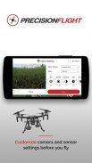
- Customizing camera and sensor settings before your flight
- Optimizing your flight plan using advanced mission controls
- Intuitive and simple one-click video recording
- Real-time tagging of frames as points of interest
- Seamless integration with PrecisionHawk’s PrecisionMapper for processing and analysis
Post-flight, drone operators can upload imagery, tagged video recordings, and other flight data to PrecisionMapper.com, for free. Create and analyze 2D and 3D orthomosaic maps, and gain access to the Algorithm Marketplace for other analytic tools including volume, NDVI, elevation, and much more.
PrecisionFlight is perfect for commercial applications of drone flights across industries like agriculture, energy, mining, insurance, and others. Save and share data safely and securely with your team across personal devices. Upload all gathered drone data and imagery to PrecisionMapper for further analysis.
PrecisionFlight is compatible with DJI’s latest drones: Matrice 200, Matrice 600, Matrice 100, Phantom 4 Pro, Mavic Pro, Inspire 2, Inspire 1, Phantom 3, Phantom 4, Phantom 4 Advanced. Please ensure your DJI drone's firmware is updated to the latest version before attempting to use PrecisionFlight.
Please remember to fly responsibly and abide by all local and federal airspace regulations.
PrecisionHawk der PrecisionFlight mobile app verwandelt eine DJI Drohne in eine erweiterte Fernerkundungswerkzeug-empowering Drohne Piloten autonom Antenne Daten zu erfassen. Erstellen Flugpläne, Video aufnehmen und erfassen Luftbilder-alle mit dem Knopfdruck.
Die wichtigsten Merkmale sind eine intuitive und einfache Flugplanung Schnittstelle; autonomer Start, Umfrage Mission und Landung; automatische Bestimmung der effizientesten Flugbahn für die Datenerfassung einschließlich Orbit Missionen um jeden Punkt von Interesse; und Echtzeit-Flugüberwachung einschließlich Höhe, Geschwindigkeit über Grund, Mission Fortschritt, Batterie und Signalstärke, GPS, Live-Video und Flug Spur.
Zusatzfunktionen:
- Erstellung von Flugplänen, einschließlich Gitter, Orbit, und Video-Capture-Modi
- Vorflugcheck und Notfall Sicherheits-Features wie Notlandung und Rückkehr zu Hause (RTH) Technologie
- Die Fähigkeit, pausieren und Missionen wieder aufnehmen
- Speicherung von Flugpläne für eine einfache Flugplan-Management
- Online-und Offline-Flugplanungsfunktionen mit Speicherung von Basiskarten für nicht-verbundene Flüge
- Customizing Kamera- und Sensoreinstellungen vor dem Flug
- Optimierung des Flugplanes erweitert Mission Kontrollen unter Verwendung von
- Intuitive und einfache Ein-Klick-Videoaufzeichnung
- Echtzeit-Tagging von Frames als Sehenswürdigkeiten
- Nahtlose Integration mit PrecisionHawk des PrecisionMapper zur Verarbeitung und Analyse
Post-Flug, Drohne Betreiber können Bilder, getaggt Videoaufnahmen hochladen und andere Flugdaten PrecisionMapper.com, kostenlos. Erstellen und analysieren 2D- und 3D-orthomosaic Karten und Sie erhalten Zugang zu den Algorithmus Marktplatz für andere analytische Tools, einschließlich Volumen, NDVI, Höhe und vieles mehr.
PrecisionFlight ist ideal für kommerzielle Anwendungen von Drohnen für Branchen wie Landwirtschaft, Energie, Bergbau, Versicherungen und andere. Speichern und teilen Daten sicher und sicher mit Ihrem Team über persönliche Geräte. Laden Sie alle gesammelten Drohne Daten und Bilder zu PrecisionMapper zur weiteren Analyse.
PrecisionFlight ist kompatibel mit DJI neuesten Drohnen: Matrice 200, Matrice 600, Matrice 100, Phantom 4 Pro, Mavic Pro, Inspire 2, Inspire 1, Phantom 3, Phantom 4 Phantom 4 Advanced. Stellen Sie sicher, Ihre DJI Drohne der Firmware auf die neueste Version aktualisiert werden, bevor PrecisionFlight zu verwenden.
Bitte denken Sie daran von allen lokalen und föderalen Luftraum Vorschriften verantwortungsvoll und halten zu fliegen.
PrecisionFlight for DJI Drones – Version 2.4.2
(12-04-2020)PrecisionFlight for DJI Drones – APK Informationen
APK Version: 2.4.2Paket: com.precisionhawk.inflightmobileNeueste Version von PrecisionFlight for DJI Drones
Weitere Versionen


 4.63
4.63


Apps in derselben Kategorie
 4.22
4.22 4.384.39
 4.02
4.02Das könnte dir auch gefallen...


